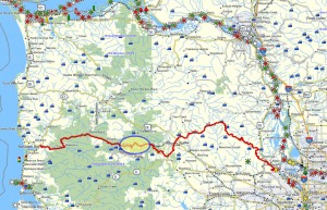
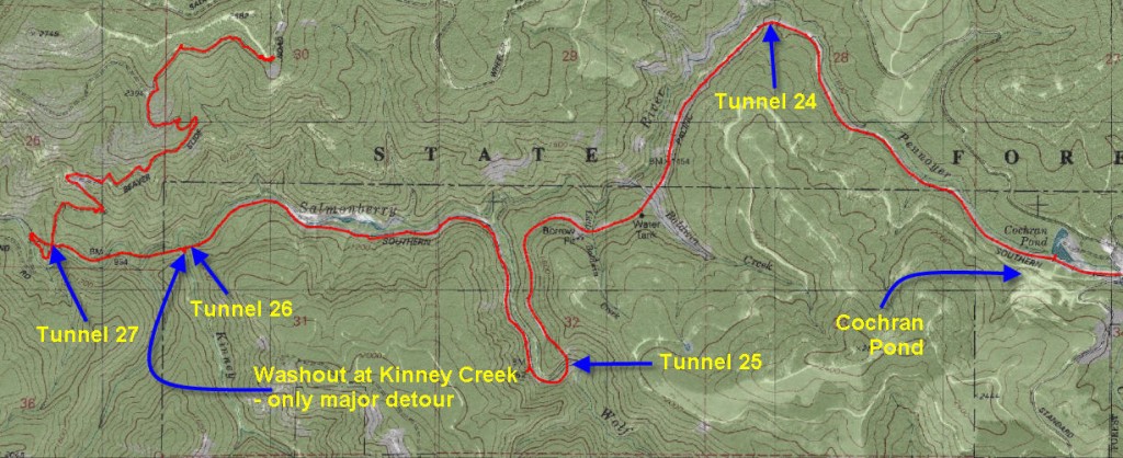
Brief Summary: This upper portion of the Salmonberry River trail extends from Cochran Pond about 6.25 miles down to where the Belding and Beaver Slide roads meet this wild river. This upper portion features a number of impressive trestle bridges and several tunnels, but there is only one moderate bushwhack to navigate. The Salmonberry passage through the Coast range is one of my favorite hikes, and the upper portion is a gentle way to approach this wild trail. This is part of the “Southern Route” that this site has surveyed. Maybe some day we will be able to preserve this trail!
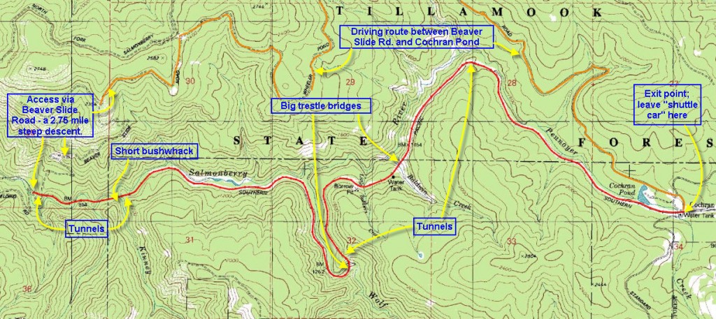 Distance: 6.25 miles one way to the bottom of Beaver Slide Road. Beaver Slide Road is 2.73 miles of straight uphill! I recommend starting at the top of Beaver Slide Road, and exiting at Cochran Pond, where you can leave the “shuttle” car.
Walk duration: 5 hours approximately
Travel time to trail head: These direction assume that you will leave a car at Cochran Pond, and will use a second car to access the top of Beaver Slide Road from whence the hike will commence. Once you’ve walked the length of Beaver Slide Road you will appreciate why we will travel in this direction and not the reverse.
Drop off car at “trail’s end”:
From the Sylvan exit on US 26 (Exit 71) at the top of the West Hills travel 33.6 miles on the Sunset Highway (US 26) to the Timber junction on US 26 and turn left (south). Travel 3 miles on this road until you reach the hamlet of Timber. As you enter the town turn right on Cochran Road (before the main road also turns right and ascends the slope) and proceed 6.8 miles southwards. As you approach the upland plateau on which Cochran pond is located you will see a large area cleared of trees.
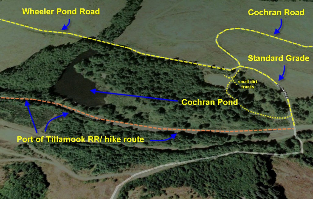 You will reach an intersection that permits you to proceed forward or turn right and ascend the hillside. The right hand turn is the Wheeler Pond Road that we will use to get to beaver Slide Road, but for now you will proceed forward and choose the more traveled track (Standard grade road) that veers off to the left. Follow this track along until you get to the train tracks. Park nearby.
Drive to “trail’s start”:
With your second car drive back to the track you came in on (Cochran Road) and take Wheeler Pond Road that heads west and uphill from that junction. This road will head up the north side of the salmonberry valley for 5.2 miles. At the crest of the ridge the Wheeler Pond Road intersects with a short road that connects to the Wheeler Cut-off Road and the Salmonberry Road. But we will ignore those roads and turn left (proceeding down the other side of the valley we just ascended) on the extension of the Wheeler Pond Road for another 4.6 miles. The Salmonberry river actually runs at the base of the valley you are following. This road has some spectacular spots where it emerges from the woods and traverses large open slopes that provide impressive views of the upper Salmonberry valley. This road always seems longer than it’s actual 4.6 miles. Eventually, end you will emerge on a flat clearing that affords views both east towards the Salmonberry River Valley and west towards the deep valley formed by the North Fork of the Salmonberry. On maps this open plateau is marked as the location of Camp Nine – however there is little to suggest any major camp.
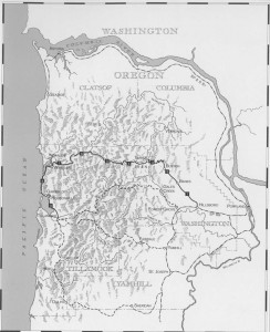 At this junction four roads join. You entered the intersection from the northeast on the Wheeler Pond Road. To your right the Salmonberry Road enters from the northwest and continues across the intersection descending towards the southwest on the far side of the clearing. But we will cross the clearing and veer to the left (southeast) entering a road that has the least traffic of all the choices presented. This is the infamous Beaver slide Road. Carefully follow this road for another .7 miles driving slowly since the road is a bit rough and potholed.
After the .7 miles the road reaches a shoulder where the track splits. The least used choice leads straight back into the copse of trees straddling the ridge top and stops. The middle choice dips sharply downhill, and the last choice curves around the end of the ridge to the right. Unless you have a very versatile and powerful four wheel drive “rig” I would suggest parking at this point. Since we will have already left one car at the Nehalem River junction, we are now ready to commence the hike by descending the middle fork of these three choices – which is Beaver Slide Road.
Elevation change: The biggest elevation change occurs on Beaver Slide Road where we lose 1600 ft over 1.75 miles! The grade at times exceeds -30% so that it’s a struggle to keep from overbalancing downwards and slipping on the rough gravel surface. No wonder it’s called the Beaver Slide Road – it’s no exaggeration.
Brief summary: Walking the length of the Salmonberry River has got to be one of the most impressive hikes in the north Coast Range, or even across all of Oregon. In my opinion the Salmonberry is one of the most beautiful and awesome rivers in the state. The upper portion of the salmonberry is much less strenuous than the lower portion for two reasons. First it’s a much shorter route – only 9 miles versus 15 miles. And secondly there is only one serious bushwhack detour required. However, walking along the railroad tracks can also be tiring. But whichever way you go you will come away from this trip with a new found respect for the unbelievable beauty of this remote mountain river.
Trail Log:
To organize the trail log I have divided the entire hike into two parts:
- The descent down Beaver Slide Road to the Salmonberry River
- The hike along the Upper Salmonberry from Beaver Slide Road to Cochran Pond
1. Beaver Slide Road descent to the Salmonberry River.
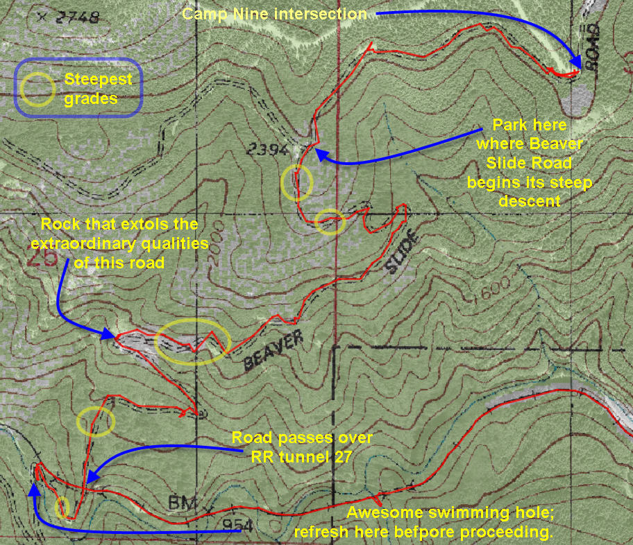 It’s a steep descent right from the beginning, where the Beaver Slide road tips off the end of the ridge at about 2400 ft in elevation. The first third of the descent winds about in a generally southeasterly direction passing through a mixed alder and hemlock forest. After about .4 miles the trail turns in a southwesterly direction and traverses down the steep incline heading towards the west.
  This traverse gets progressively steeper with the grade in the -25% to 29% range and at places approaching a 48% grade! The total length of the descent is about 1.75 miles – dropping more than 1,500 feet at nearly a -20% grade over the length of the road.
At the corner a huge rock marks the switchback and spray paint commentators have been kind enough to express their true feelings about the Beaver Slide Road. Beyond the rock a steep chute channels a water fall down a virtual cliff face. Just stop to listen; you’ll hear it. I wouldn’t venture too far out from the bend, lest you lose your footing and life…
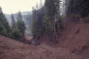
Below the rock we’re traveling in a southeasterly direction along  the flank of the mountain, but it soon switches back to a westerly descent. At this point we reach the only relatively level area in the climb as we cross a small stream that feeds a small Skunk weed bog. But as we turn the corner the road drops precipitously again and begins a straight line slide along a ridge. On either side the hill drops down steeply. On the right side you can glimpse the RR tracks amongst the trees, and on the left hand side you can hear the river lashing its way down the steep trench at the bottom. The tracks actually tunnel (Tunnel #27) under Beaver Slide Road. If you were to arrive here in mid-winter in the midst of a storm you would be walking into what amounts to a 21 mile washing machine churning boulders, tree trunks and huge
  maelstroms between the steep embankments – bending and crushing everything in its way!
But during more clement weather this hard to reach river bottom is a place of solitary beauty, resplendent in the verdant shade of the overhanging fir trees. At the base of this road you will find a track leading down to one of the best swimming holes on the river. Take some time to rest here and if the weather permits dip your skinny butt in the blue-green waters of the Salmonberry!
2. From the base of Beaver Slide Road to Cochran Pond.
Having rested and perhaps swum in the Salmonberry, it’s now time to start following the railroad tracks up to Cochran Pond – a journey of about 6.5 miles with a rise in elevation of only 930 feet – a mere hop, skip and a jump compared the elevation gain you’d be facing by returning back up the Beaver Slide Road.
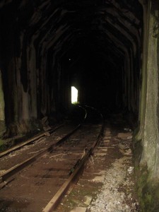
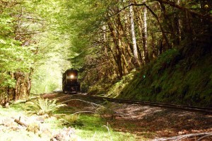
Our hike starts by going through Tunnel 27, over which the beaver Slide Road descends. This short tunnel has some debris piled out side the entrance, but is pretty clean walking 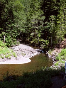 throughout. I would recommend taking a flashlight just to make it easier to see that the rail road ties are, and to avoid stepping into the muddy road bed in between them.
As we emerge on the other side the railroad bed is soon covered with debris and we begin to follow a small trail that twists through the vegetation covered slide area. ATV enthusiasts that have descended the Beaver Slide Road have carved out a route for part of this way, and you should have no trouble following the route, even in the absence of rail lines – which are presumably buried beneath the slide materials.
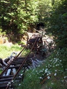
According to the map the original rail lines crossed the river along this stretch of water (a third of a mile from Tunnel 27), but apparently the water got the best of the crossings – and they have vanished. As a consequence the trail hugs the northern shore and rejoins the rails after they recrossed to that side of the river. A short distance on, they cross to the southern side on a surviving bridge (a half mile from Tunnel 27). A short distance on (.15 miles) we reach the Kinney Creek crossing. This bridge remains in place, but is mangled beyond use and we are forced to hug the slope on our right and follow a narrow track heading up into Kinney Creek to our right. Follow this narrow footpath (this was presumably the end of the
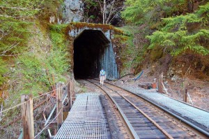
line for the ATV’s) up the slope until it drops down into the bed of Kinney Creek. Before crossing the stream bed spot the narrow track that leads up the opposite side and plan your route across the boulder-filled creek bottom so that you reach the base of that track up the embankment. These tracks are narrow and steep, but also mercifully short. Cresting the top of the slope on the far side we have arrived at the mouth of Tunnel 28.
The damage to this small bridge is an example of the massive damage that this railroad line has sustained over the years. The nearby photo from “Just Peachy’s” photostrean on FlikR illustrates what the tunnel entrance and trestle looked like prior to the 2007 storm damage. By the way, Just Peachy’s FlikR photos are worth looking up – they’re just peachy!
In 2008, the Wild Salmon Center issued a report on the damage from the 2007 storm, entitled, The Salmonberry River: Finding a Solution to the Landslide-Prone Railroad on the Salmonberry River. In it they detail the damage that has occurred to the railroad and in turn it’s impact on the health of the river system:
“Storms and the landslides they trigger have severely damaged the rail line several times in the past 15 years, three times quite severely. In 1992, the line experienced flood damage just as an initial effort to upgrade the line due to a one-time federal grant was in process. In 1996, the line was damaged by a storm and 88 separate repair sites required $13 million to repair, with the majority of funding coming from the federal government. In December 2007, another storm obliterated or impaired large sections of the line. Three bridges sustained damage and one tunnel is blocked with mud and debris. Construction and fill material needed to repair the line may cost as much as $30 million.”
As for the tunnel “blocked with mud and debris“, we found this to be inaccurate unless it was referring to the small pile of debris slightly blocking the entrance to Tunnel 27 – see earlier photo of Tunnel 27. According to the aforementioned report, “The 42,000-acre Salmonberry watershed is the single largest producer of wild steelhead in the Nehalem and supports a wild population that, at times, may exceed 2,000 fish.”
It goes on to say that the:
“Steelhead in the Salmonberry spawn later than other steelhead runs on the coast and some exhibit astounding migration skills by navigating waterfalls as high as 12 feet. The large size of Salmonberry steelhead, approaching upwards of 30 pounds, makes them unique to this region. Larger wild fish may be the evolutionary result of the river’s formidable physical environment that favors size and strength.”
Needless to say the violent forces of nature are known to wreak havoc on this canyon, and it seems unlikely that the railroad will be rebuilt. The Wild Salmon Center’s report also shows how the existence of the railroad also contributes to the damage that accrues to the river system that shares this narrow defile.
Emerging from the tunnel we follow a relatively straight stretch that parallels the river in an easterly 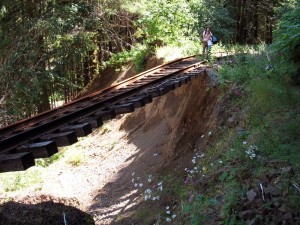 direction. About 3/4 of a mile onwards we begin to encounter significant erosion that has undercut the tracks and forces the hiker to skirt the eroded embankment along the uphill side. We continue along another half mile of hiking the tracks “on again, off again” depending upon the erosion. At this point the tracks begin to curve to the right and enter Wolf Creek Canyon.
Wolf Canyon is a major tributary to the Salmonberry and the rail road tracks climb partially up the Creek before crossing and doubling back
to the main stem of the Salmonberry River. This canyon is one of the most landslide prone areas in the watershed. In the previously mentioned report on the damages sustained by the Salmonberry railroad in the 2007 storms and subsequent floods, the Wild Salmon Center discusses the role of forestry practices in contributing to both railroad damage and also to aquatic habitat.
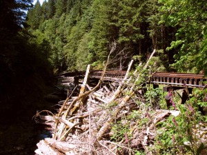
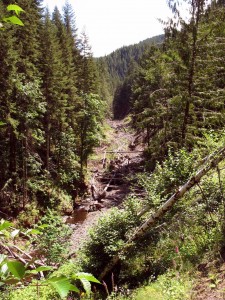
Even today, years after the frightful 2007 maelstrom that devoured this canyon the awesome power of the water and fallen hillsides can be seen in the bleached detritus littering Wolf Creek.
About 51/4 miles from our starting point we begin to approach the upper end of the Wolf Creek loop and the tracks cross Wolf Creek on an impressive wooden trestle that looms high above the forest canopy below. 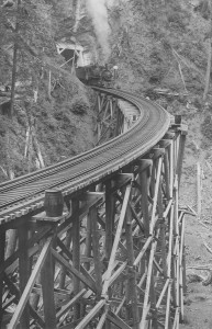 Immediately thereafter, we enter into another tunnel. On the far side of Tunnel 25 we continue northwards “doubling back” along Wolf Creek before the tracks turn east again to parallel the main stem of the Salmonberry River. At this point we can witness the dramatic erosion that has stripped away the hillside upon which the trail tracks used to run.
As the tracks turn eastward they soon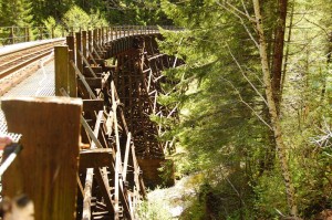 cross Little Baldwin Creek on another well built trestle, at the end of which is an old tanker car that has been “tagged” by Ogre and his friends on their way through in ’09. More of his and others’ work can be seen throughout the length of the Salmonberry with the most impressive efforts down near the confluence with the Nehalem River. They must have run out of spray paint at the upper end?
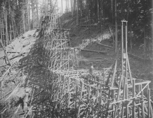 Moving right along we soon arrive at the water tower (.2 miles beyond the Little Baldwin trestle) and just short of the Baldwin Creek bridge. Completed in July of 1911, the Big Baldwin Bridge is the tallest structure on the line measuring 167 feet in height and 520 feet in length. In addition to building more than sixty on this line the Pacific Railway & Navigation Company cut massive cuts up the faces of the steep slopes up to 120 feet in height that required the excavation of thousands of cubic feet of rock and rubble without the aid of machinery. Using pick and shovel the laborers on the line loosened the rock and piled it into small dump carts that were pulled away by donkeys.
At this point the landscape seems to flatten out a bit as we approach the top of the watershed. The embankments are farther away from the river and washouts are rare. In fact as we proceed out of sight of the river itself, it splits and the salmonberry heads NE into the valley we had to ascend and descend on Wheeler Pond road. By the time we rejoin the now small stream that heads up to Cochran Pond, it’s no longer the Salmonberry but has become Pennoyer creek.
By now you legs are aching and your getting tired of this commentary and only wish to see Cochran Pond where you’ve stashed your 2nd car…
From Baldwin Creek to Cochran Pond it’s only 2.5 miles with no washouts, detours or other annoyances. Even at a leisurely pace it’ll take no more than an hour!
In all, it’s a great hike with some impressive sights and evidence of human engineering skills that take one’s breath away. But even after the 5-6 hours it takes to complete this hike you’ll be tired, but also filled with lots of worthwhile memories!
As a final thought…wouldn’t it be nice to turn this into a recognized and maintained linear trail???!!!


You’ve done a great job documenting these hikes along the Salmonberry. I have been doing this as a 2-day boy scout backpacking trip, with cars shuttled from Cochran to the Nehalem. I’ve got a bunch of pictures posted here: http://www.europa.com/~layport/salmonberry
I would love to see this trail maintained. But quietly. I am afraid that with too much publicity, those bridges and trestles will be dismantled in the name of safety because I doubt any official agency will want to spend the money to maintain them.
Are you aware the Port has filed with the Feds to abandon the right-of-way?
Steve
Actually there’s a serious effort afoot to do a rails to trail conversion of the Salmonberry stretch of the trail. The Port of Tillamook has bought into it, as has the Governor, Cycle Oregon and the Department of Forestry – so we may get to keep the trestles and the eerie tunnels. Yes, you’re right if we fix this trail it may not be quite so adventurous, but more people will get to enjoy it. Stay tuned and keep your boots laced!
It sucks that your pictures are no longer available.
Here are some I took for the first few miles my girlfriend and I did yesterday (3/1/2013). http://www.flickr.com/photos/25654895@N06/sets/72157632903574500/
I am very interested in keeping this hike, hikable. the brush is rapidly moving in on the tracks. Once they start budding out, it’s going to get difficult. Any suggestions on who to contact at making this a recognized trail?
Jeff:
There’s an organized effort to turn this into a state recognized (and funded) trail. There’s currently a feasibility study being assembled that will begin the multi-year work of turning this into a multi-user trail. In the meantime, bring your rose clippers, and we’ll all do the same to keep the pesky alders at bay. Jim
It really is amazing how fast nature fills in. We went out there just last Spring and already your photos look so different from mine. Love that Baldwin trestle. Hope it gets to stay if they do convert it to a more “accessible” trail.
I most recently went out on the Baldwin trestle only last month in the company of an Oregon Parks Ranger and he seemed to think that the trestle could be maintained. They did so for the big trestle in the Banks-Vernonia trail.
But here’s a question for you. What do you think made the huge gouge into the wooden ties between the rails? It’s mostly visible on the trestle, although I did not some gouging elsewhere, but not as deeply or as persistently as on the trestle?
Jim
My husband and I were wondering about that too. Our theory is that the ties on bridges and trestles don’t get replaced at the same rate as others along the track. We were thinking it might be similar to the way bridges on the highway don’t get repaved as often as the adjacent sections that are on solid ground.
Perhaps years of chains dangling, or a couple rides with a broken piece scraping along, made the gouge all along the track, but through replacement we now only see its trace on the bridges?
Hi Jim,
The gouges you see down he middle of the tracks is where the train derailed, at some point. The flanges on the wheels made the gouge. You’ll see this sort of gouge on all the older railways.
I’m not sure about this explanation. The gouges are consistent along the entire length of the PR&N – even on the trestles – where one would expect derailments would be less common, or at least the catastrophic consequences would have been documented. We do know of many derailments and even one on the Little Baldwin Trestle, but these marks are consistent with abrasion by a dangling object, like a chain or part of the couplings…
Great shots. In a few weeks some friends and I are going to try this. Are you shots from the upper Salmonberry or the lower? Thanks.
I think my first comment is in the wrong place. I just looked at your pictures and loved them. My friends and I are going to try this soon. Did you do the upper or lower Salmonberry?
Thanks
The pictures in the Upper Salmonberry are from that portion of the gorge; those in the Lower Salmonberry section are, as the title suggests, in the lower portion of the Salmonberry gorge. Glad you liked them. The pictures are weak facsimiles when you see the entire Gorge itself!!
Jim
I’ve done both on several occaisions, and I often hike down the North Fork of the salmonberry. Another favorite is to hike out to “windy gap” – high above the Salmonberry Gorge. I’ll be posting aome guides for those destinations soon. Just finished the manuscript for the new book that will include many of these trails – so now I have time again to start posting hikes on the website.
Jim
I went to the upper Salmonberry today and tried to find the upper and lower parking spots you describe above. I found the Cochran Pond parking area near the RR tracks, but the roads are very poorly marked. I think I drove up the Wheeler Pond Road for 5.2 miles, but I can’t be sure, since there were numerous intersecting roads and none were marked. I may have taken a wrong turn. Nevertheless, I didn’t find Camp Nine or Beaver Slide Road. I tried this on my own a few months ago (before I discovered your website) and I got lost that time as well. I’m willing to try again, but it’s pretty frustrating when the roads aren’t marked. I don’t have GPS in my truck. Any suggestions? Thanks.
We did the exact same thing on Wheeler Road for a good 3 or 4 miles. We ended up at the parking site near Cochran Pond as well and went down the track for several miles. It’s a fun hike. Too bad we don’t have two cars.
My pictures have moved to a more permanent location. I have photos from two different years at http://www.raftalot.com/salmonberry2012/ and http://www.raftalot.com/salmonberry2011/. The brush in 2012 was much worse then in 2011. I hiked it in 2010 too, much less plant growth then. It won’t be long before the “trail” is impassable, especially with additional landslides that are inevitable.
I recently learned the Oregon Coast Scenic Railroad hopes to reopen the tracks as far as Enright for scenic excursions from Garibaldi.
Questions? Email me at salmonberry (at) raftalot.com.
Nice pictures. looks like the rain got you, but you had plenty of company with whom to share the pleasure! 😉
Thanks so much for the wonderful writings and photos. My buddy and I hiked from Cochran Pond 47 years ago all the way down to the Nehalem fishing all the way down the Salmonberry. We were 17 at the time. That was in the summer of 1966.We caught some nice trout in the river almost too pretty to keep we let a lot go keeping just what we could eat each day. We started the first day after arriving fishing the Cochran Mill Pond then camped that night and a herd of elk did also right next to us! At the RR tracks next to the pond back then there was a phone in a concrete shelter that connected one to an operator because I called my folks in Portland. I haven’t been down there for decades so I didn’t know about the washout, wow what a difference! It was so pristine back then and really an easy hike down the tracks all the way to the Nehalem except for getting down to the river in the deep canyons to fish. There were native cutthroat trout to 18 inches in those deep pools. Thanks again for the memories!
Patrick
Has anyone hiked this recently? What does the trail/rails look like now? Would it still be quite easy to navigate? I think this is a hike my husband would enjoy and I was thinking about taking him for his birthday. Thanks!
I have just completed the 21 miles from Cochran to the Nahalen River in two days with no problems. The trail on the railroad tracks is heavy with alders, obscuring views in many places. That been said, the scenery is fabulous. The trails created to get around the destroyed bridges and tracks are easy to follow. Some kind souls have left rope at Kinney Ck to get up a steep bank, and there is even a railroad ladder placed on another steep bank to help you out.
The trestles on Baldwin Ck and Wolf Ck are amazing, with small side trails to get under them for those full size pictures. All the tunnels are clear and easy to get through except for one, it has a lot of cave in, but again easy to get over.
The river runs slow and shallow a great deal of the time. There are lots of deep pools for a dip, but access to the river itself always requires a scramble down the bank.
There are plenty of nice places to spend the night or rest between the tracks and the river. I hoisted my pack into the trees to keep the bears from getting into it. I never saw a bear but I sure smelled them more than once.
The entire trip was good backpacking experience, lots of history, views and cameras full of pictures. I will give a very detailed outline with pictures on my blog, Peter Skyhouse, some time in the next week or so.
Lastly, safety is a concern. Tell people where you are going, and travel with a partner. Gloves and long pants and shirts are the uniform of the day, otherwise your going to get beat up from the brush. The salmonberry bushes are not thornless but they are everywhere, hence the name of the river.
It is a fantasy trip!! Peter
My son, nephew and I often fished the Salmonberry in the 1970’s and early 80’s. Those were the days you could also trout fish. I understand the reasons but it is where I taught Mike to fly fish and respect the fishery. Anyway, many good memories on the hikes which usually went from the mouth to the North Fork and then back down. Lots of large cutthroat in June and into July. The folks at Cochran had some sox hanging out front for many years and the track and tunnels were all in tact. The occasional train came by albeit very slowly! Many great memories.
I, and three other friends, all seniors, hiked the upper Salmonberry last year from Cochran Pond down to Wolf Creek Trestle. I would not do that again. At several locations banks have completely washed away leaving sections of the track some over 100 feet long, suspended over deep draws some distance from the washout, and no accessible route around, over or below the tracks on the bank itself. We crossed gandydancing from one tie to the next. Miss a tie, or slip on it and pitch over the tracks and it will get very ugly. Take care. Can check with the Forest Grove office of the Tillamook Forest, they take care of that area.
The Salmonberry was a favorite of my son and I in the 70’s and early 80’s. Our trips were from the mouth to the South Fork and then a day fishing back down. Always remember the consecutive dated bridges and tunnels above Enright. There was often a family in the cabin at Enright and the same sox hung on the line for many years, I guess to make you think someone was there. After my Son’s death I fished mainly in the section from the North Fork up to Beaver Slide or down to the South Fork.
It sure seems like the rail is gone but I hope a trail remains. a truly great area.
October 2015. Logging operations are blocking beaver slide rd during the week.